PHYSICAL GEOGRAPHY AND ENVIRONMENTAL GEOSCIENCE
Type of resources
Keywords
Publication year
Topics
-
Up to date information about the extent and location of surface water provides all Australians with a common understanding of this valuable and increasingly scarce resource. Digital Earth Australia Waterbodies shows the wet surface area of waterbodies as estimated from satellites. It does not show depth, volume, purpose of the waterbody, nor the source of the water. Digital Earth Australia Waterbodies uses Geoscience Australia’s archive of over 30 years of Landsat satellite imagery to identify where over 300,000 waterbodies are in the Australian landscape and tells us the wet surface area within those waterbodies. It supports users to understand and manage water across Australia. For example, users can gain insights into the severity and spatial distribution of drought, or identify potential water sources for aerial firefighting during bushfires. The tool uses a water classification for every available Landsat satellite image and maps the locations of waterbodies across Australia. It provides a timeseries of wet surface area for waterbodies that are present more than 10% of the time and are larger than 2700m2 (3 Landsat pixels). The tool indicates changes in the wet surface area of waterbodies. This can be used to identify when waterbodies are increasing or decreasing in wet surface area. Refer to Krause et al. 2021 for full details of this dataset. https://doi.org/10.3390/rs13081437
-
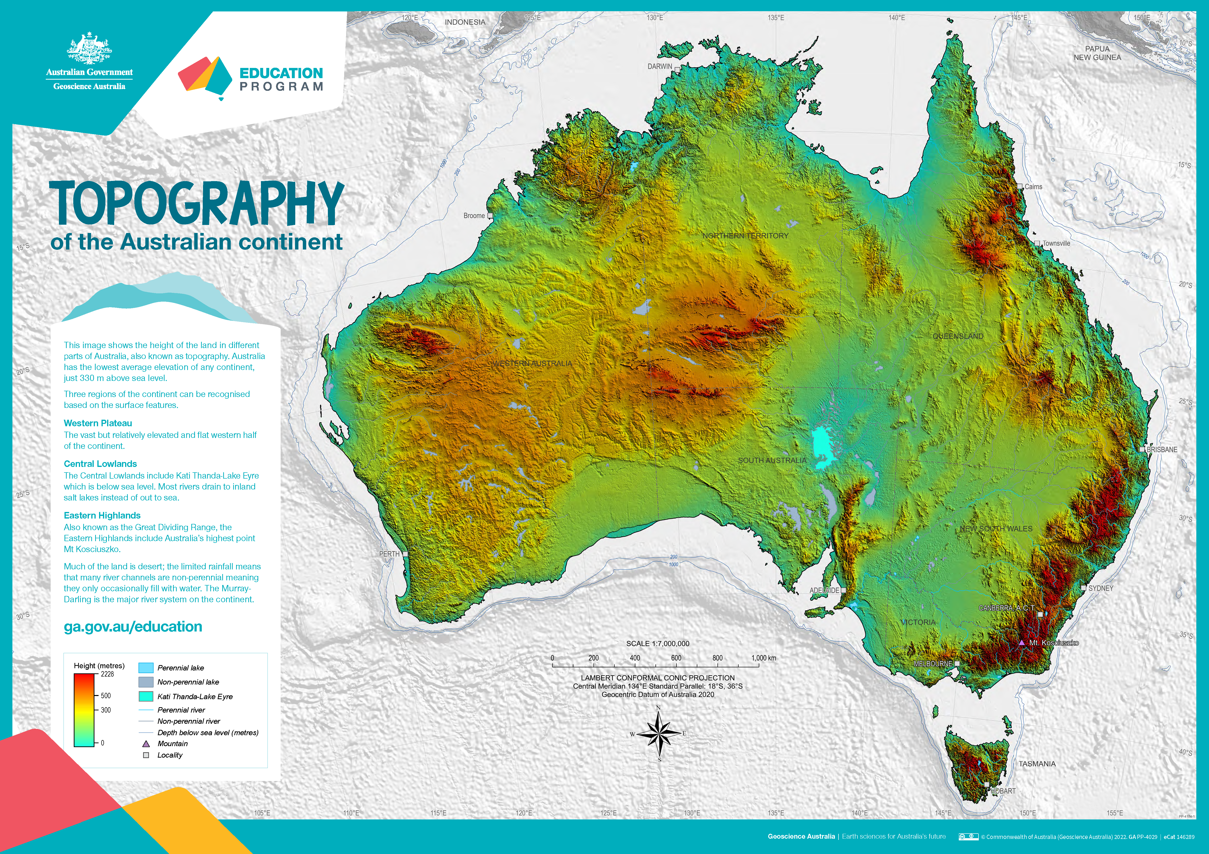
The poster uses a colourful digital elevation model to show the topography of the Australian continent. Low land is shown in green, higher land is yellow and orange and the highest parts of the country appear red. The map also shows perennial and non-perennial lakes and rivers as well as the location of the highest point in Australia and Kati Thanda-Lake Eyre at below sea level. The surrounding 200 m and 1000 m seabed depths contours are shown against a grey background. An accompanying text box outlines the three main physical regions of the county: the western plateau, central lowlands and eastern highlands. The poster is designed to be printed at A1 size which is 1:7 000 000 scale.
-
Managed aquifer recharge (MAR) enhances recharge to aquifers. As part of the Exploring for the Future Southern Stuart Corridor project, remotely sensed data were used to map regolith materials and landforms, and to identify areas that represent potential MAR target areas for future investigation. Nine areas were identified, predominantly associated with alluvial landforms in low-gradient landscape settings. The surface materials are typically sandy, or sandy and silty, with the prospective areas overlying newly identified groundwater resources associated with Paleozoic sedimentary rocks of the Wiso and Georgina basins. The workflow used here can be rapidly rolled out across broader areas, and can be supplemented by higher-resolution, longer time-series remote-sensing data, coupled with data analytics, modelling and expert knowledge. Such an approach will help to identify areas of the arid interior that may be suitable for MAR schemes that could supplement water for remote communities, and agricultural and other natural resource developments. <b>Citation:</b> Smith, M.L., Hostetler, S. and Northey, J., 2020. Managed aquifer recharge prospectivity mapping in the Northern Territory arid zone using remotely sensed data. In: Czarnota, K., Roach, I., Abbott, S., Haynes, M., Kositcin, N., Ray, A. and Slatter, E. (eds.) Exploring for the Future: Extended Abstracts, Geoscience Australia, Canberra, 1–4.
-
The gnssanalysis Python package is designed to provide the public with a source of useful python functions and classes that help with processing of GNSS observations. The functionality found within the package includes: - reading of many standard file formats commonly used in the geodetic community including SP3, SNX, RNX, CLK, PSD, etc. into pandas dataframes (Also writing certain file formats) - transformation of data, for example datetime conversions, helmert inversions, rotations, transforming geodata from XYZ to longitude-latitude-altitude, etc. - functions for the download of standard files and upload to other sources (e.g. s3)
-
This Perth Basin dataset contains descriptive attribute information for the areas bounded by the relevant spatial groundwater feature in the associated Hydrogeology Index map. Descriptive topics are grouped into the following themes: Location and administration; Demographics; Physical geography; Surface water; Geology; Hydrogeology; Groundwater; Groundwater management and use; Environment; Land use and industry types; and Scientific stimulus. The Perth Basin is a complex geological region extending along Australia's southwest margin for about 1,300 km. It comprises sub-basins, troughs, terraces, and shelves, hosting sedimentary rocks with coal, oil, gas, and significant groundwater resources. Off the coast of Western Australia, it reaches depths of up to 4,500 m, while its onshore part extends up to 90 km inland. The basin is bounded by the Yilgarn Craton to the east, and the Carnarvon and Bremer basins to the north and south. The basin's history involves two main rifting phases in the Permian and Late Jurassic to Early Cretaceous, creating 15 sub-basins with varying sedimentary thickness due to compartmentalization and fault reactivation. The sedimentary succession mainly comprises fluviatile Permian to Early Cretaceous rocks over Archean and Proterozoic basement blocks. Differences exist between northern and southern sequences, with the south being continental and the north featuring marine deposits. During the Permian, faulting and clastic sedimentation dominated, with marine transgressions in the north and continental rocks in the south. The Triassic saw a similar pattern, with the southern succession being continental and the northern succession showing marine deposits. The Kockatea Shale became a primary hydrocarbon source. The Jurassic period witnessed marine incursions in the central basin, while the Late Jurassic experienced sea level regression and deposition of the Yarragadee Formation. The Cretaceous saw the formation of the Early Cretaceous Parmelia Group due to heavy tectonic activity. The southern basin had a marine transgression leading to the Warnbro Group's deposition with valuable groundwater resources. Post-Cretaceous, Cenozoic deposits covered the basin with varying thicknesses. Overall, the Perth Basin's geological history reveals a diverse sedimentary record with economic and resource significance.
-
This Carnarvon Basin dataset contains descriptive attribute information for the areas bounded by the relevant spatial groundwater feature in the associated Hydrogeology Index map. Descriptive topics are grouped into the following themes: Location and administration; Demographics; Physical geography; Surface water; Geology; Hydrogeology; Groundwater; Groundwater management and use; Environment; Land use and industry types; and Scientific stimulus. The Carnarvon Basin is a large sedimentary basin covering the western and north-western coast of Western Australia, stretching over 1,000 km from Geraldton to Karratha. It is predominantly offshore, with over 80% of the basin located in water depths of up to 4,500 m. The basin is elongated north to south and connects to the Perth Basin in the south and the offshore Canning Basin in the north-east. It is underlain by Precambrian crystalline basement rocks. The Carnarvon Basin consists of two distinct parts. The southern portion comprises onshore sub-basins with mainly Paleozoic sedimentary rocks extending up to 300 km inland, while the northern section consists of offshore sub-basins containing Mesozoic, Cenozoic, and Paleozoic sequences. The geological evolution of the Southern Carnarvon Basin was shaped by multiple extensional episodes related to the breakup of Gondwana and reactivation of Archean and Proterozoic structures. The collision between Australia and Eurasia in the Mid-Miocene caused significant fault reactivation and inversion. The onshore region experienced arid conditions, leading to the formation of calcrete, followed by alluvial and eolian deposition and continued calcareous deposition offshore. The Northern Carnarvon Basin contains up to 15,000 m of sedimentary infill, primarily composed of siliciclastic deltaic to marine sediments from the Triassic to Early Cretaceous and shelf carbonates from the Mid-Cretaceous to Cenozoic. The basin is a significant hydrocarbon province, with most of the resources found within Upper Triassic, Jurassic, and Lower Cretaceous sandstone reservoirs. The basin's development occurred during four successive periods of extension and thermal subsidence, resulting in the formation of various sub-basins and structural highs. Overall, the Carnarvon Basin is a geologically complex region with a rich sedimentary history and significant hydrocarbon resources. Exploration drilling has been ongoing since 1953, with numerous wells drilled to unlock its hydrocarbon potential.
-
This Surat Basin dataset contains descriptive attribute information for the areas bounded by the relevant spatial groundwater feature in the associated Hydrogeology Index map. Descriptive topics are grouped into the following themes: Location and administration; Demographics; Physical geography; Surface water; Geology; Hydrogeology; Groundwater; Groundwater management and use; Environment; Land use and industry types; and Scientific stimulus. The Surat Basin is a sedimentary basin with approximately 2500 m of clastic fluvial, estuarine, coastal plain, and shallow marine sedimentary rocks, including sandstone, siltstone, mudstone, and coal. Deposition occurred over six cycles from the Early Jurassic to the Cretaceous, influenced by eustatic sea-level changes. Each cycle lasted 10 to 20 million years, ending around the mid-Cretaceous. Bounded by the Auburn Arch to the northeast and the New England Orogen to the southeast, it connects to the Clarence-Moreton Basin through the Kumbarilla Ridge. The Central Fold Belt forms its southern edge, while Cenozoic uplift caused erosion in the north. The basin's architecture is influenced by pre-existing faults and folds in the underlying Bowen Basin and the nature of the basement rocks from underlying orogenic complexes. Notable features include the north-trending Mimosa Syncline and Boomi Trough, overlying the deeper Taroom Trough of the Bowen Basin and extending southwards. The Surat Basin overlies older Permian to Triassic sedimentary basins like the Bowen and Gunnedah Basins, unconformably resting on various older basement rock terranes, such as the Lachlan Orogen, New England Orogen, and Thomson Orogen. Several Palaeozoic basement highs mark its boundaries, including the Eulo-Nebine Ridge in the west and the Kumbarilla Ridge in the east. Paleogene to Neogene sediments, like those from the Glendower Formation, cover parts of the Surat Basin. Remnant pediments and Cenozoic palaeovalleys incised into the basin have added complexity to its geological history and may influence aquifer connections. Overall, the Surat Basin's geological history is characterized by millions of years of sedimentation, tectonic activity, and erosion, contributing to its geological diversity and economic significance as a source of natural resources, including coal and natural gas.
-
This Carpentaria Basin dataset contains descriptive attribute information for the areas bounded by the relevant spatial groundwater feature in the associated Hydrogeology Index map. Descriptive topics are grouped into the following themes: Location and administration; Demographics; Physical geography; Surface water; Geology; Hydrogeology; Groundwater; Groundwater management and use; Environment; Land use and industry types; and Scientific stimulus. The Carpentaria Basin is a vast intra-cratonic sedimentary basin situated on and offshore in north-eastern Australia, covering around 550,000 square kilometres across Queensland and the Northern Territory. It comprises predominantly sandstone-rich rock units deposited during sea level highs from the Late Jurassic to Mid Cretaceous. The basin overlies a heterogeneous Proterozoic basement and is separated from contemporaneous sedimentary structures by basement highs and inliers. Four main depocentres within the larger Carpentaria Basin form four major sub-basins: the Western Gulf Sub-basin, Staaten Sub-basin, Weipa Sub-basin, and Boomara Sub-basin. While the basin is extensive and continuous in Queensland, it becomes more heterogeneous and discontinuous in the Northern Territory. Remnants of the basin's stratigraphy, referred to as the Dunmarra Basin, are found along the Northern Territory coast and inland. The depositional history commenced during the Jurassic with down warping near Cape York Peninsula, resulting in the Helby beds and Albany Pass beds' concurrent deposition. The basin experienced marine transgressions during the Cretaceous, with the Gilbert River Formation widespread and the Wallumbilla Formation occurring during sea level highs. The Carpentaria Basin's strata are relatively undeformed and unmetamorphosed. The Northern Territory sequence displays slightly different stratigraphy, limited to the height of the Aptian marine transgression above the Georgina Basin. The Walker River Formation and Yirrkala Formation represent key units in this area, outcropping as tablelands and mesas largely unaffected by tectonism.
-
This Money Shoal Basin dataset contains descriptive attribute information for the areas bounded by the relevant spatial groundwater feature in the associated Hydrogeology Index map. Descriptive topics are grouped into the following themes: Location and administration; Demographics; Physical geography; Surface water; Geology; Hydrogeology; Groundwater; Groundwater management and use; Environment; Land use and industry types; and Scientific stimulus. The Money Shoal Basin is a large passive margin basin in northern Australia, mainly located in the offshore Arafura Sea. Its sedimentary succession spans from the Mesozoic to the Cenozoic era, reaching a maximum thickness of 4,500 m in the northwest but thinner, less than 500 m, in central and eastern areas. The basin overlays the Neoproterozoic to Permian Arafura Basin and older Proterozoic rocks of the Pine Creek Orogen and McArthur Basin. It is bounded by the Bonaparte Basin to the west and the Carpentaria Basin to the east. The southern margin of the basin occurs onshore and is an erosional feature, although scattered remnant outliers of Money Shoal Basin rocks occur in isolated areas to the south and south-east of Darwin. The northern parts remain less explored, situated beyond Australia's maritime border with Indonesia. The basin's Mesozoic sediments were deposited during passive margin subsidence, and consequently remain relatively undeformed. Compressional tectonics were later initiated during the Cenozoic collision between the Indo-Australian plate and Southeast Asia, causing minor structural disruptions along the northwest margin of the Australian plate. Most of the sediments in the basin were deposited in shallow to marginal marine environments, with minor evidence for short-lived episodes of deltaic and fluvial deposition in some areas. The sedimentary packages in the offshore basin are divided into four groups: Troughton Group equivalent, Flamingo Group equivalent, Bathurst Island Group, and Woodbine Group equivalent. Onshore, the stratigraphic succession is limited to the Plover Formation equivalent, Bathurst Island Group, and the Eocene Van Diemen Sandstone. The Troughton Group extends from the Bonaparte Basin into western parts of the Money Shoal Basin, and chiefly consists of sandstone. The Flamingo Group, identified offshore, is considered equivalent to its Bonaparte Basin counterpart, characterized by sandstone and mudstone deposits, suggesting fluvial and deltaic settings. The Bathurst Island Group dominates onshore, composed mainly of fine-grained claystone, marl, and siltstone. The Woodbine Group is the uppermost unit, and is equivalent to the Woodbine Group of the Bonaparte Basin, consisting of Cenozoic deposits, primarily sandstone and claystone, indicating shallow marine and deltaic environments.
-
This North-east Australian Fractured Rock Province dataset contains descriptive attribute information for the areas bounded by the relevant spatial groundwater feature in the associated Hydrogeology Index map. Descriptive topics are grouped into the following themes: Location and administration; Demographics; Physical geography; Surface water; Geology; Hydrogeology; Groundwater; Groundwater management and use; Environment; Land use and industry types; and Scientific stimulus. In fractured rock aquifers, groundwater is stored in the fractures, joints, bedding planes and cavities of the rock mass. About 40 per cent of groundwater in Australia is stored in fractured rock aquifers, and much of this may be available for irrigation, town water supplies, stock watering and domestic use. Approximately 33% of all bores in Australia are in fractured systems, representing about 10 per cent of total extraction. Groundwater yield is extremely variable, and dependent on the distribution of major fractures. However, rates of groundwater movement in fractured rock systems are difficult to quantify. Characterising groundwater flow in fractured rock aquifers is difficult with existing techniques, and groundwater flow direction can be related more to the orientation of fractures than to the hydraulic head distribution. Recharge in fractured rock aquifers is usually local and intermediate. The Queensland fractured rock is taken to be that part of the northern elements of the Eastern Fracture Rock provinces that extends from the southern part of the Laura Basin, south to the state boundary with New South Wales, and inland as far as the Bundock and Galilee Basins. It comprises the Mossman, Thomson and New England Orogens, and related Provinces. These include: i) The Mossman Orogen, including the Hodgkinson Province, and the Broken River Province; ii) The Thomson Orogen, comprising Neoprotozoic – Early Paleozoic Provinces, including the Anakie Province, Barnard Province, Charters Tower Province, Greenvale Province, and Iron Range Province; and iii) The New England Orogen, including the Gympie Province, Connors-Auburn Province, Yarrol Province, Wandilla Province, Woolomin Province, Calliope Province, Marlborough Province, and Silverwood Province